Arbor Doctor vs the Groundhog 2025 edition
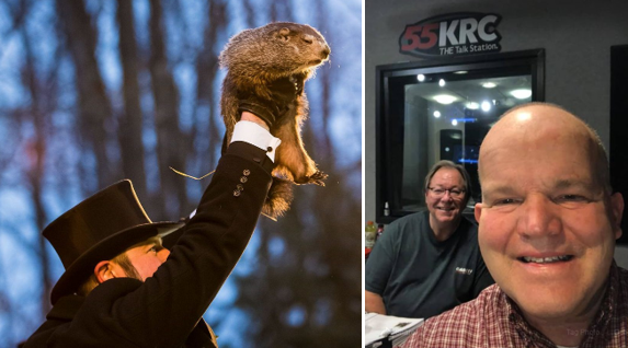
It has become an annual tradition. Every year, sometime around Groundhog Day, I, the Arbor Doctor, join Ron Wilson on his In The Garden radio show on 55 WKRC and iHeartRadio for the battle of the Groundhog Day predictions, pitting my late winter prediction against Punxsutawney Phil and many other furry beasts such as Buckeye Chuck.
The Groundhog Day tradition, observed in the United States and Canada, is based on the Pennsylvania Dutch superstition that if a groundhog emerges from its burrow on this day and sees its shadow, it will retreat to its den and winter will go on for six more weeks. If it does not see its shadow, spring will arrive early. While the track record for these furry beasts is not particularly good it is a fun and well known tradition.
So, what about this year?
Drum roll please.
The Arbor Doctor does not see his shadow, indicating an early arrival of spring. With a caveat.
Let’s look at it.
Way back in the fall we were seeing indications of a colder and snowier winter in the Ohio Valley. Indeed, that came to fruition with above normal snowfall in November and December, albeit with warmer than normal temperatures, followed by the coldest and snowiest January in about 3 decades with in excess of 14 inches of snow and an average temperature which was over 4° below the 30 year average.
Toward the end of January the cold weather pattern broke, warmer temperatures moved in, and the snow melted leaving many of us to ask if there would be any more winter. Then came Groundhog Day when the question would be answered, or at least addressed.
The cold weather pattern did indeed break down at the end of January. By the beginning of February, a warm and spring-like weather pattern was in place for much of the southern and eastern parts of the country. This is an active weather pattern with an active jet stream.
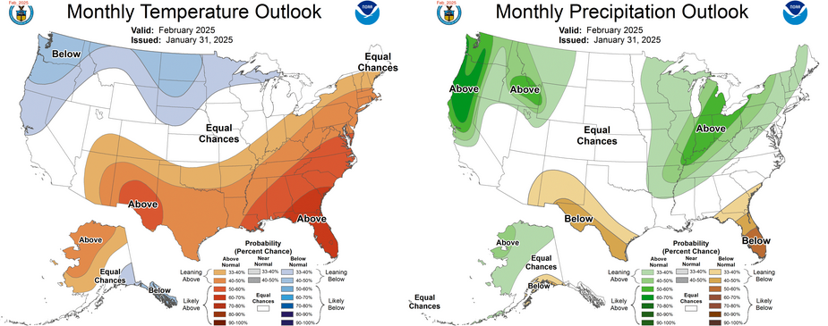
Projected February temperature and precipitation trends.
It appears this pattern will continue in one form or another for the balance of February and if that happens temperatures will generally remain mild in the south and the east parts of the US with colder weather in the Pacific Northwest, Northern California, the northern plains and the northern Great Lakes.
This very active weather pattern lends itself toward heavy precipitation in the Ohio and Tennessee river valleys and an increased severe weather and flood potential. In fact, it appears that this entire spring will have a heightened severe weather potential in the Mississippi valley, Tennessee Valley, and Ohio Valley.
This does not mean there will be no snow. In fact, it is likely that to the northwest of the storm track, with abundant snow cover and cold air in place in Canada and the northern plains, significant snow storms will impact areas of the mountain west, the high plains, the northern Mississippi valley, and the Great Lakes. Since the jet stream is fluid and moves around it is certainly possible that any given storm could push further south and produce snow or ice. It is unlikely that there will be any more long, sustained periods of snow and ice in the south or east.
The fly in the ointment is that some computer models are indicating the potential for another Arctic outbreak later in February. This is by no means a sure thing but it is something we will need to keep our eye on. If this were to happen, very cold air, with the potential for snow or ice, could move back into the Midwest and the east and may push into parts of the South. A large snow event would be possible in the east in this scenario but is by no means a sure thing, or even likely, this far out.
It is unlikely that such a cold wave, if it occurs at all, would be nearly as long lasting as what we saw in January. Once that cold wave would move out spring would resume. Again, this is only a possibility, and it is by no means a sure thing.
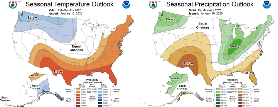
Projected temperature and precipitation depatures February through April.
Meteorological spring, which most closely follows climatology and nature, begins on March 1. While relatively short periods of cold and snow are still possible it appears likely that we will have an early spring with frequent precipitation and an above normal severe weather potential in and near the Ohio Valley.
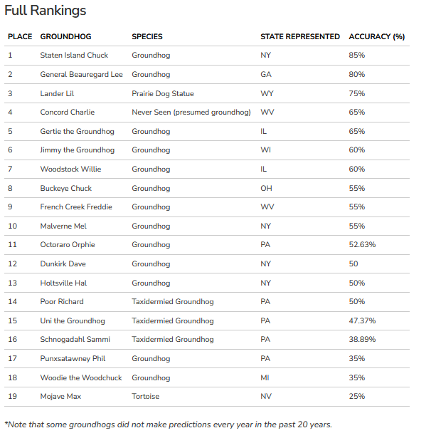
2025 Groundhog predictions:
Punxsutawney Phil sees his shadow, handlers say, predicting 6 more weeks of wintry weather
Buckeye Chuck says spring is coming on Ohio's Groundhog Day 2025
Grading the groundhogs | National Oceanic and Atmospheric ...