Freeze Warning in effect Monday night AND Tuesday night.
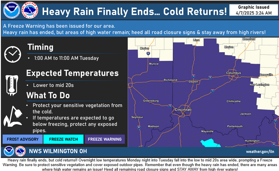
A Freeze Warning is in effect for the Cincinnati tristate Monday night and Tuesday night.
A number of hours well below freezing, in the 20's, means trouble for very sensitive plants.
Most native plants, as well as daffodils, tulips, hyacinths, and pansies, will be just fine.
Fruit production in fruit trees which are already in bloom may be significantly damaged. Japanese maples which have already budded out and have young leaves will also be quite vulnerable.
If possible, run a sprinkler on these from late night into the early morning. You may also cover these trees with a light weight sheet. Covering them with plastic may cause more harm than good, and could cause significant damage.
URGENT - WEATHER MESSAGE
National Weather Service Wilmington OH
306 AM EDT Mon Apr 7 2025

INZ050-058-059-066-073>075-080-KYZ089>100-OHZ026-034-035-042>046-
051>056-060>065-070>074-077>082-088-071515-
/O.UPG.KILN.FZ.A.0001.250408T0500Z-250408T1400Z/
/O.NEW.KILN.FZ.W.0001.250408T0500Z-250408T1500Z/
Wayne-Fayette-Union-Franklin-Ripley-Dearborn-Ohio-Switzerland-
Carroll-Gallatin-Boone-Kenton-Campbell-Owen-Grant-Pendleton-
Bracken-Robertson-Mason-Lewis-Hardin-Mercer-Auglaize-Darke-Shelby-
Logan-Union-Delaware-Miami-Champaign-Clark-Madison-Franklin-
Licking-Preble-Montgomery-Greene-Fayette-Pickaway-Fairfield-
Butler-Warren-Clinton-Ross-Hocking-Hamilton-Clermont-Brown-
Highland-Adams-Pike-Scioto-
Including the cities of Downtown Cincinnati, Rising Sun,
Circleville, Newark, Georgetown, Brooksville, Wheelersburg,
Dayton, Batesville, Lancaster, Mount Olivet, Head Of Grassy,
Franklin, Springboro, Augusta, West Jefferson, Erlanger,
Richmond, Middletown, Springfield, Vanceburg, Burlington,
Fairborn, Fort Thomas, Maysville, Mount Carmel, Tipp City,
Tollesboro, Pike Lake, Beavercreek, Camp Dix, Milford, Minster,
Aurora, Greenfield, Falmouth, Osgood, Kettering, Celina,
Washington Court House, Wapakoneta, Owenton, Piketon, Eaton,
Milan, West Union, Mason, Piqua, Manchester, London, Highland
Heights, Blanchester, Brookville, Peebles, Warsaw, Greenville,
Hidden Valley, Alexandria, Delaware, Wilmington, Bellevue,
Williamstown, Hamilton, Greendale, Downtown Columbus,
Chillicothe, Oxford, Versailles, Mount Repose, Florence, Xenia,
Summerside, Coldwater, Bellefontaine, Troy, Landen, Hillsboro,
Camden, Dillsboro, Carrollton, Lebanon, Ripley, Connersville,
Mount Orab, Sidney, Logan, Liberty, Newport, Oakbrook, Vevay,
Withamsville, Dry Ridge, St. Marys, Downtown Dayton, Marysville,
Kenton, Day Heights, Fairfield, New Bremen, Waverly, West College
Corner, Lawrenceburg, Covington, Butler, Ada, Crittenden, Seaman,
Portsmouth, Independence, Pickerington, Urbana, Plain City,
Mulberry, Winchester, Aberdeen, and Bright
306 AM EDT Mon Apr 7 2025

...FREEZE WARNING IN EFFECT FROM 1 AM TO 11 AM EDT TUESDAY...

* WHAT...Sub-freezing temperatures falling into the lower to mid 20s.

* WHERE...Portions of east central and southeast Indiana, northeast
  and northern Kentucky, and central, south central, southwest, and
  west central Ohio.

* WHEN...From 1 AM to 11 AM EDT Tuesday.

* IMPACTS...Frost and freeze conditions could kill crops, other
  sensitive vegetation.

PRECAUTIONARY/PREPAREDNESS ACTIONS...

Take steps now to protect tender plants from the cold.