Pay attention. Moderate risk for severe storms and tornadoes now as far east as Oxford and Harrison, Ohio. Flood threat.
Back To Weather Blog
Pay attention. Moderate risk for severe storms and tornadoes now as far east as Oxford and Harrison, Ohio. Flood threat.
Apr 2, 2025
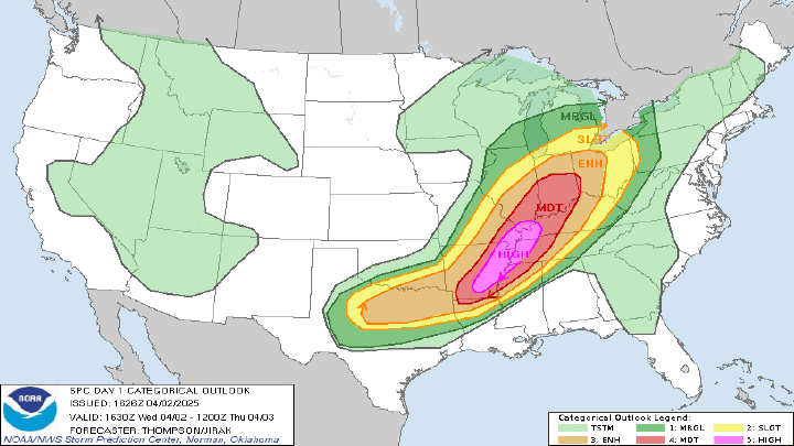
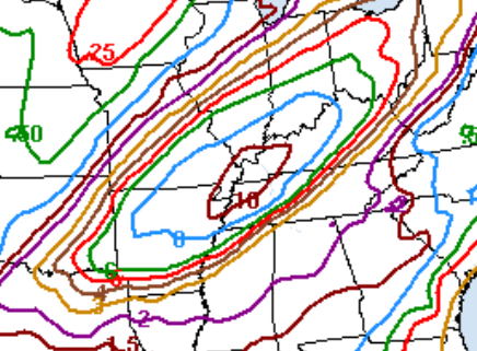
...THERE IS A HIGH RISK OF SEVERE THUNDERSTORMS THIS AFTERNOON INTO
   EARLY TONIGHT FROM EASTERN ARKANSAS INTO THE LOWER OHIO VALLEY...
...MODERATE RISK FOR SOUTHEAST INDIANA, OXFORD AND HARRISON, OHIO, AND CARROLTON KY...

   ...SUMMARY...
   A tornado outbreak is expected this afternoon into early tonight
   from parts of the lower Mississippi Valley into the Mid-South and
   lower Ohio Valley. Numerous tornadoes, along with multiple EF3+
   tornadoes, appear likely. In addition, tornadoes, significant severe
   wind gusts, and large hail to very large hail will be possible
   across a broad area from north Texas northeastward to the southern
   Great Lakes.
Hazardous Weather Outlook
National Weather Service Wilmington OH
443 AM EDT Wed Apr 2 2025

INZ050-058-059-066-073>075-080-KYZ089>099-OHZ026-034-035-042>044-
051>053-060>062-070>072-077>079-031000-
Wayne-Fayette-Union-Franklin-Ripley-Dearborn-Ohio-Switzerland-
Carroll-Gallatin-Boone-Kenton-Campbell-Owen-Grant-Pendleton-Bracken-
Robertson-Mason-Hardin-Mercer-Auglaize-Darke-Shelby-Logan-Miami-
Champaign-Clark-Preble-Montgomery-Greene-Butler-Warren-Clinton-
Hamilton-Clermont-Brown-
443 AM EDT Wed Apr 2 2025

...WIND ADVISORY REMAINS IN EFFECT FROM 10 AM THIS MORNING TO
MIDNIGHT EDT TONIGHT...
...FLOOD WATCH REMAINS IN EFFECT FROM THIS EVENING THROUGH SUNDAY
MORNING...

This Hazardous Weather Outlook is for east central Indiana,
southeast Indiana, northern Kentucky, southwest Ohio and west
central Ohio.

.DAY ONE...Today and tonight.

Severe storms will be possible this evening into tonight.

Please listen to NOAA Weather Radio or go to weather.gov on the
Internet for more information about the following hazards.

   Wind Advisory.
   Flood Watch.

.DAYS TWO THROUGH SEVEN...Thursday through Tuesday.

Please listen to NOAA Weather Radio or go to weather.gov on the
Internet for more information about the following hazards.

   Flood Watch.

Tornado outlook

Severe Wind outlook

Severe hail outlook


Heavy rain will begin on Wednesday and continues through the weekend as a frontal boundary stalls out over the Ohio Valley in a southwest to northeast orientation. Repeated rounds of heavy rain will fall on the same areas bringing significant flooding. The WPC 7-day precipitation forecast highlights the southwestern basin where the highest totals are expected over the next week. This will be a WIDESPREAD, HIGH IMPACT EVENT.
![]()