Pay attention. Significant Severe Weather Threat Late Sunday. More severe weather later this week plus flooding threat (
Pay attention. Significant Severe Weather Threat Late Sunday. More severe weather later this week plus flooding threat (
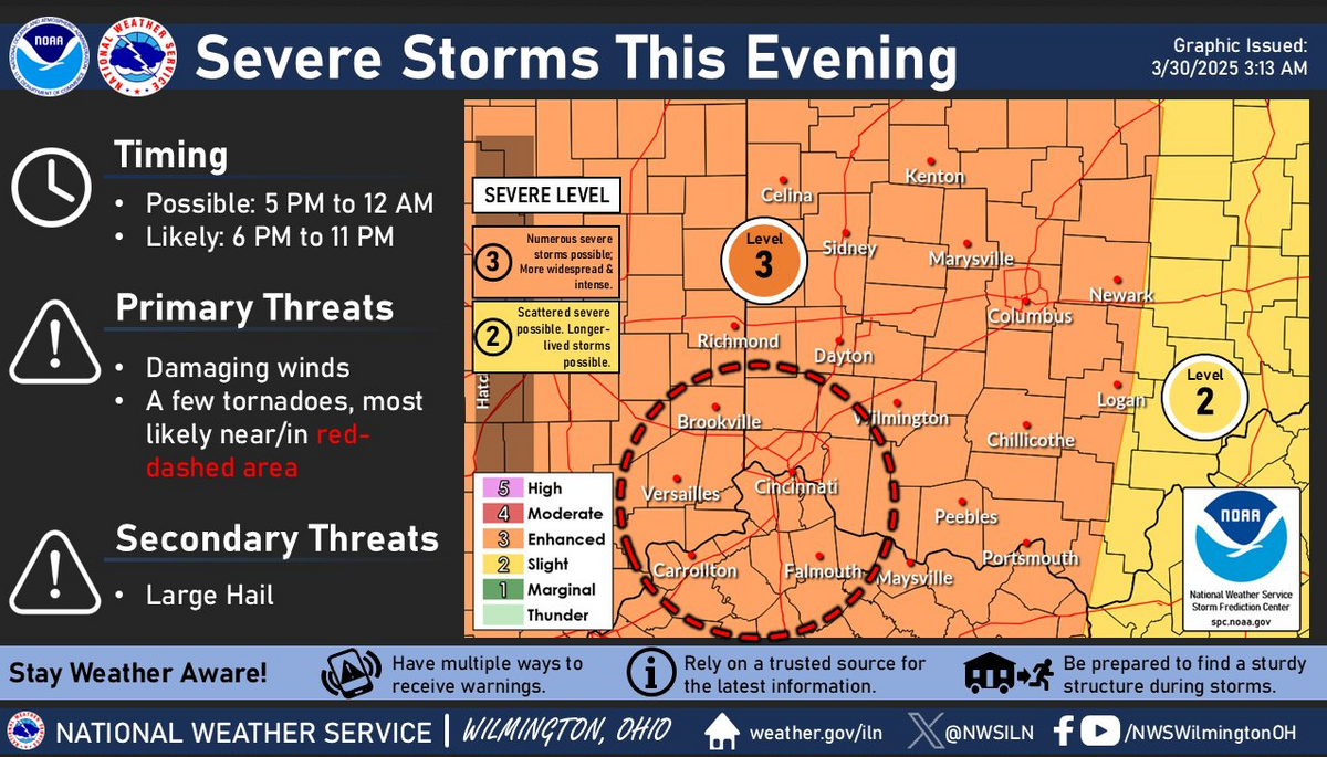
Severe storms are likely across large parts of the local area this evening, with all hazards possible. Most, if not all, of the severe threat should come to an end by midnight, even as a few storms linger through the overnight.
Do not depend on Facebook for timely warnings. NOAA weather radio and local media are the best sources for current breaking weather information.


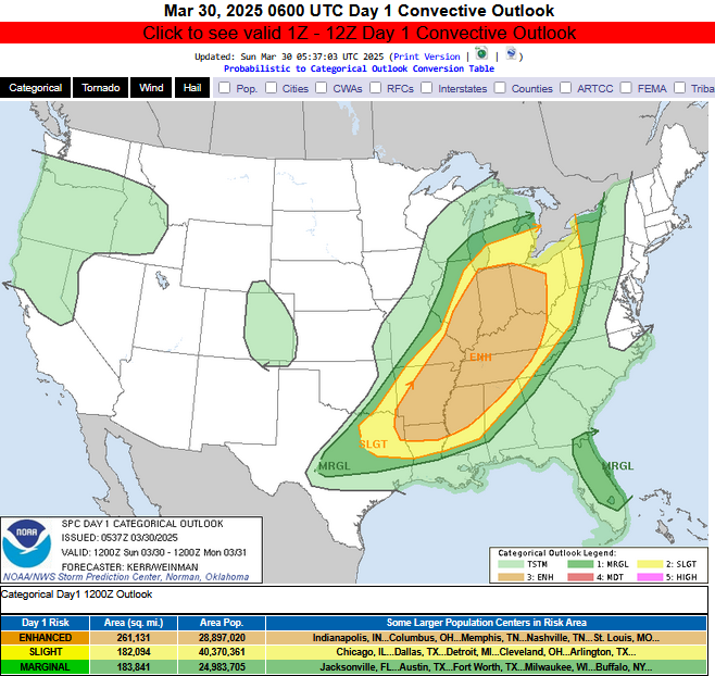
Day 1 Convective Outlook
   NWS Storm Prediction Center Norman OK
   1237 AM CDT Sun Mar 30 2025

   Valid 301200Z - 311200Z

   ...THERE IS AN ENHANCED RISK OF SEVERE THUNDERSTORMS THIS AFTERNOON
   THROUGH TONIGHT ACROSS MUCH OF SERN IL...IN...WRN AND CENTRAL
   OH...SERN MO...CNTRL AND ERN AR...KY...TN...NWRN AL...NRN AND CNTRL
   MS...NRN LA...NERN TX...

   ...SUMMARY...
   Thunderstorm development is likely to become widespread across the
   Ohio Valley southwestward through the Tennessee and lower
   Mississippi Valleys this afternoon into tonight.  Initially, this
   activity will pose a risk for large large hail.  A few tornadoes are
   also possible, before damaging wind gusts become the more prominent
   potential severe hazard this evening into tonight.

Sunday tornado risk

Sunday severe wind risk

Sunday damaging hail risk

Monday severe weather outlook

Tuesday severe weather outlook

Wednesday Severe Weather Outlook

Thursday severe weather outlook

Sunday rain forecast. 0.75-1.5 inches in the Cincinnati tristate.

Wednesday-Thursday rainfall forecast. An additional 2-4 inches of rainfall in the Cincinnati tristate.

Friday-Saturday. An additional 1-2 inches of rainfall in the Cincinnati tristate.

7 day rainfall forecast. 5-7 inches of rain in the Cincinnati trisate. 15 inches is possible in western Kentucky and western Tennessee.
Of course, these are computer model projections and placement could easily shift north or south, and amounts may be a bit heavier or lighter, but this is a very concerning signal which could lead to significant flooding in the Ohio River valley.
![]()