Significant severe weather risk later Wednesday then flooding concerns
Back To Weather Blog
Significant severe weather risk later Wednesday then flooding concerns
Mar 31, 2025

Wednesday severe weather risk.
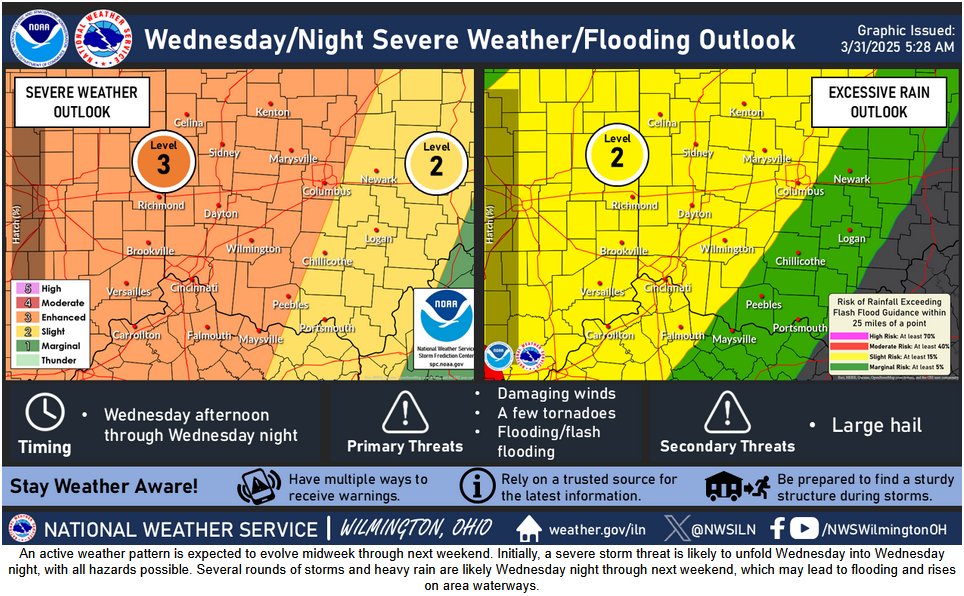
...THERE IS AN ENHANCED RISK OF SEVERE THUNDERSTORMS FROM THE LOWER
   GREAT LAKES THROUGH THE MID MISSISSIPPI VALLEY AND THE ARKLATEX...

   ...SUMMARY...
   An outbreak of severe storms is possible Wednesday and Wednesday
   night from the Lower Great Lakes, the Mid MS Valley and the
   ArkLaTex. Severe wind gusts, very large hail, and significant
   tornadoes are expected.

Thursday severe weather risk
Severe thunderstorms appear likely from Northeast TX, through AR/LA and into the Mid MS/OH Valleys.
Several additional rounds of showers and storms are expected through Saturday. The repeated rounds of storms and heavy
rain may lead to flooding and rises on area waterways.

Rainfall through midnight Wednesday. 1.75-3 inches in the Cincinnati tristate

Rainfall forecast midnight Wednesday to midnight Friday. 2.5-4.5 inches in the Cincinnati tristate.

Rainfall forecast midnight Friday to midnight Sunday. 1.25-2.25 inches in the Cincinnati tristate.

7 day rainfall totals 5-8 inches for Cincinnati tristate.