Worst Drought Since 1988 Worsening in Ohio
The big story, and developing story, for much of Ohio horticulture and agriculture is drought conditions which have risen to historic and disastrous levels in 22 Ohio counties. Last week, the United States Department of agriculture issued a natural disaster declaration for 22 Ohio counties.
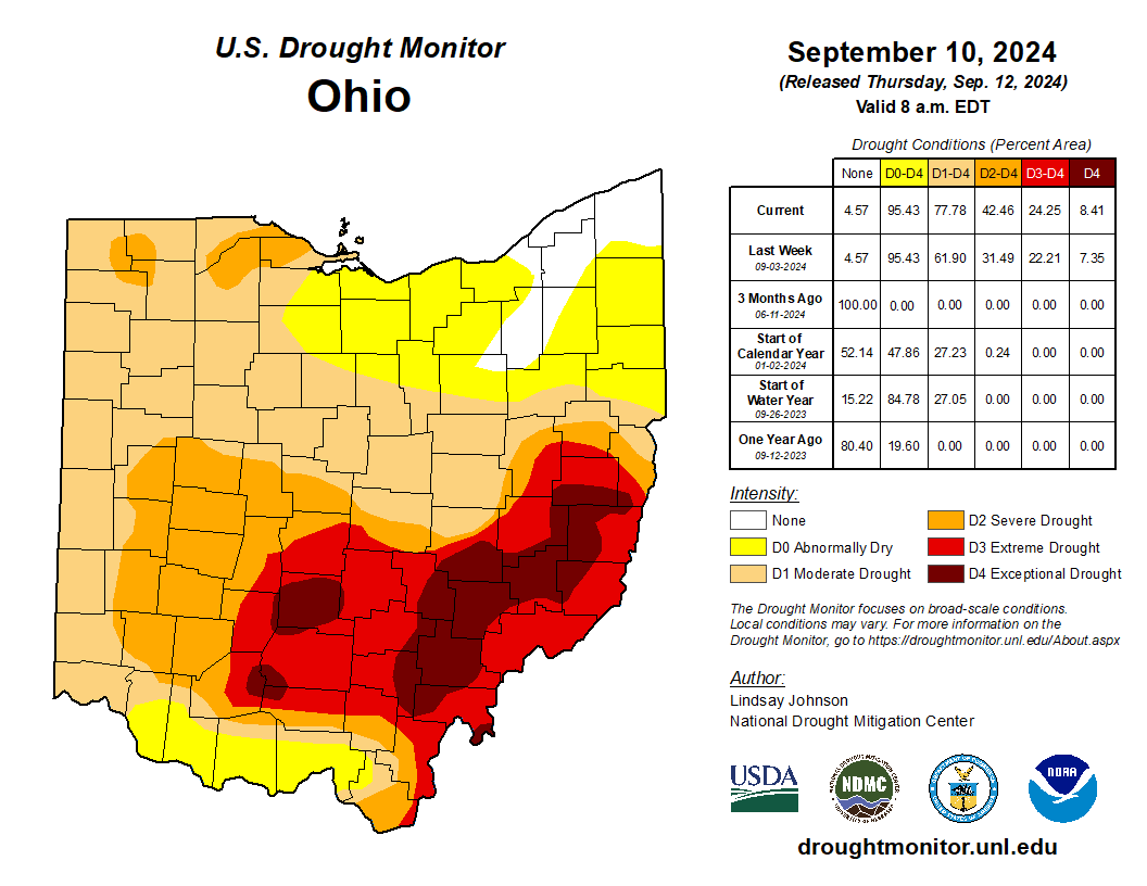
Extreme and now exceptional drought has developed in parts of southeast and southeast-central Ohio. Conditions have only worsened over the past two weeks and projections are gloomy.
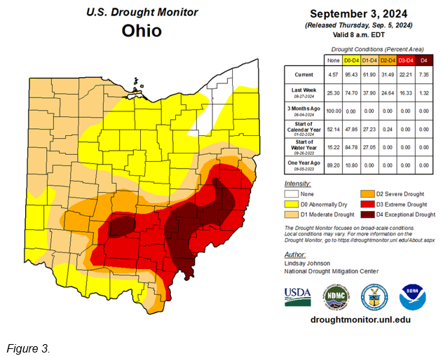
The D4 exceptional drought designation is the most extreme level of drought in the US Drought Monitor (Figure3) and has not been seen in the state of Ohio during the 21st century. As of September 3, over 7% of the state of Ohio was designated as D4 exceptional drought. According to state climatologist Aaron Wilson this level of drought is only seen once every 50 to 100 years in Ohio.
In addition to the exceptional drought areas, over 22% of the state is now designated as being at least D3 extreme drought, over 31% of the state is designated as being in at least D2 severe drought, 62% of the state of Ohio is categorized as being in at least D1 moderate drought, over 95% of the state of Ohio is categorized as being at least abnormally dry, and only 4.57% of the state, an area in northeast Ohio, is categorized as having no dry or drought conditions.
Wilson commented that the current drought is likely the worst drought in the state of Ohio since 1988 and this will rank as one of the worst droughts in Ohio history.
Please remember to water…correctly!
Water once per week, one inch per week, under the entire branch spread, in the absence of rain, May through November. Either rainfall or your watering should equal the one inch per week. Do not water if the soil is already moist. Put out a sprinkler and a straight sided soup can or rain gauge and measure one inch per week. Measure the rainfall which falls in your yard. Your trees don’t care what fell at the airport!
If burlap was left on new trees, it will repel water and the tree or shrub may die. Be sure burlap and twine are removed from the top of all root balls. If your landscaper disagrees, refer him or her to the American National Standards Institute (ANSI) industry standard for installation of landscape plants.
To the extent possible recycle fallen leaves back into the soil around the trees and maintain mulch around the trees to a radius of at least 3-5 feet. Keep mulch off trunks. Use a coarse textured mulch. Avoid triple shredded mulch. Aged arborist wood chips ( https://getchipdrop.com/ ), mulched and composted leaves, pine bark, and pine straw are all good. Very finely ground mulches such as triple ground hardwood mulch are not beneficial and may inhibit moisture and oxygen exchange.
Drought: How Dry Seasons Affect Woody Plants>>>
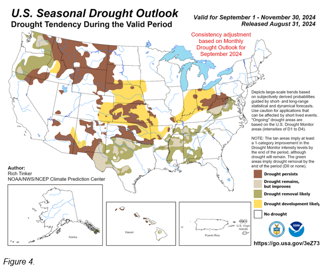
Unfortunately, The US Seasonal Drought Outlook (Figure 4) for the fall indicates expanding drought conditions over most of the rest of Ohio, and conditions that will only worsen in areas that already have drought. This outlook is based on the overall expected weather pattern. The one thing that could change this outlook in a major way would be if a tropical system were to move into Ohio from the Gulf Coast. Such systems can dump copious quantities of rain over Ohio but thus far they seem to be few and far between this year despite projections of an active season.
The Secretarial natural disaster designation allows the United States Department of Agriculture (USDA) Farm Service Agency (FSA) to extend much-needed emergency credit to farm operators in primary counties and contiguous counties through FSA emergency loan assistance. Emergency loans can be used to meet various recovery needs including the replacement of essential items such as equipment or livestock, reorganization of a farming operation, or to refinance certain debts. FSA will review the loans based on the extent of losses, security available, and repayment ability. The deadline for producers in designated primary and contiguous counties to apply for loans is April 28, 2025.
According to the U.S. Drought Monitor, these counties suffered from a drought intensity value during the growing season of 1) D2 Drought-Severe for eight or more consecutive weeks or 2) D3 Drought-Extreme or D4 Drought-Exceptional.
Impacted Area: Ohio and West Virginia
Triggering Disaster: Drought
Application Deadline: April 28, 2025
Primary Counties Eligible:
Ohio – Athens, Belmont, Fairfield, Fayette, Gallia, Guernsey, Harrison, Highland, Hocking, Jackson, Jefferson, Madison, Monroe, Morgan, Muskingum, Noble, Perry, Pickaway, Pike, Ross, Vinton and Washington Counties
Contiguous Counties Also Eligible:
Ohio – Adams, Brown, Carroll, Champaign, Clark, Clinton, Columbiana, Coshocton, Franklin, Greene, Lawrence, Licking, Meigs, Scioto, Tuscarawas, and Union Counties
West Virginia – Brooke, Cabell, Hancock, Marshall, Mason, Ohio Pleasants, Tyler, Wetzel, and Wood Counties
More Resources
On farmers.gov, the Disaster Assistance Discovery Tool, Disaster Assistance-at-a-Glance fact sheet, and Loan Assistance Tool can help you determine program or loan options. To file a Notice of Loss or to ask questions about available programs, contact your local USDA Service Center.
USDA is an equal opportunity provider, employer and lender.
Select Drought Condition Monitoring Reports from CoCoRaHS

Athens 4.6 ESE
Station Number OH-AT-21
1.40" of rain in the past 7 days will likely prevent further deterioration of conditions. Our two perennial streams are not flowing; however some pools have returned enough that cree chubs killed by the dryness are now floating. Pasture grasses remain dormant. Second cut hay will likely be a loss.
Condition Severely Dry
Date Mon Sep 02 2024
Waterford 3.4 SSW
Station Number OH-WS-12
Conditions at Station OH-WS-12 are extremely dry, only a total of 2.05" of scattered rain in the past 38 days. The South Branch of Wolf Creek in Wolf Creek Watershed at the Station Location is very low at standing water in most areas of Waterford and Watertown. Trees are suffering extreme stress and leaves are turning yellow, brown and dropping very early. Lawns are drying up and dying. Local Golf Course has brown greens and are having to water almost daily and the "water" hazard ponds on the course have dried up and are now filled with "cat tails" and marsh grass. Wildlife shows significant stress as well. The birds at feeders have slowed in feeding, and plumage is showing signs of dull molting. Field Corn fields in the area around Station OH-WS-12 in Beverly, Watertown and Waterford Ohio are turning brown and dying. Hay fields are showing signs of browning as well. With lack of rain, mostly dry conditions and low humidity primarily the Forest and Brush Fire conditions are VERY HIGH and thoughts toward to cautioning public and measures should be put into place.
Condition Severely Dry
Date Fri Aug 30 2024
Grove City 1.9 SSE
Station Number OH-FR-111
Report 08/25-8/31/2024 Precipitation: 0“ of measurable precipitation for the week. Temps ranged from highs between 91° and 101°, lows from 62° to 70°. Plant/lawn conditions: Grass is super stressed all over the neighborhood. Plants are wilting but trying to stay alive. Summary: No rain all week, or for the past 12 days. Things are very stressed here.
Condition Severely Dry
Date Sun Sep 01 2024
Raymond 3.5 NW
Station Number OH-UN-4
Report Crops are dead or dying. The lawn is brown and crunchy. Leaves are falling from trees. Hot this week, hit 94, 95, 97 degrees - with very dry winds too.
Condition Severely Dry
Date Sat Aug 31 2024
Wilder 0.2 ESE (SE metro Cincinnati)
Station Number KY-CB-10
Report Station KY-CB-10 has entered the D2- SEVERE DROUGHT Category today. Many of the trees are starting to lose some of their leaves. Approximately 80 to 85 percent of the trees are showing drought stress such as shriveling leaves. The pond level is very low and is nearly at the lowest level that was reached during the great drought of 2010. Only 0.10" rain last 2 weeks. There are large cracks in many of the unwatered lawns. The lawns are very brown except for the people who have been watering their lawns. The grass is completely dormant. Some sidewalks are showing signs of settling forming more trip hazards. Some people in the local area are having foundation problems with their homes. A homeowner will have to get a partial new driveway on Guardian Drive which had settled some 4 to 6 inches by their garage door which was due to this drought. A sidewalk had settled some 4 to 6 inches on Shelter View Court by their front porch stoop and will likely have to do repairs soon. The local streams are completely dried up except for the Ohio & Licking Rivers in the northern half of Campbell County, except for sewage treatment plant water. Many of the trees are showing great signs of drought stress at the University of Northern Kentucky. I had to water all my evergreen trees and my tree in my front yard. I had to water all my bushes and to water around my garage where the foundation is shallower. Serious fire risk of lawns catching on fire from illegally tossed cigarette butts due to extremely dry grass. High fire risk of grilling outdoors unless lawn is watered within 15-foot radius of the grill. No water restrictions yet since our water comes from the Ohio River which is feed by many local rivers where the there are many areas of ample rainfall in the Ohio watershed. I had to thoroughly water my compost piles due to potential fire danger. Approximately 40 percent of the normal rainfall during the past 90 days.
Condition Severely Dry
Date Mon Sep 02 2024
Cheviot 3.4 W
Station Number OH-HM-24
Report 0.60 inch of rain in the past week and 2.37 inches since August 1. This is much below normal. We were well on our way to the Moderately Dry category before the 0.60 inch fell. The 0.60 inch mostly fell in a couple of training thunderstorms several days ago which covered very little real estate. Therefore, as has been the case all summer, most of the area has descended deeper into drought than this location. Despite that, I am seeing drought stress here in vegetation with brown areas in lawns.
Condition Mildly Dry
Date Tue Sep 03 2024
Lexington 2.3 NNW
Station Number OH-RC-18
Report Temp Avg Hi/Lo 84.1/66.3°F, RA this past week 0.18", Soybean leaves are turning yellow. Grass growing slower normal this week, Trees are dropping leaves, Intermittent stream 500' E of Station - Flow: None
Condition Moderately Dry
Date Sun Sep 01 2024
Alliance 4.8 SSW
Station Number OH-ST-12
Report Our dry spell continues with just 0.28" of rain this week and 1.79" in the last 30 days. Showers have been hit-or-miss and when they do hit, they've been brief. Corn and soybean fields are starting to shut down. Leaves on smaller trees and bushes continue to yellow and drop. Most of the big trees in the area are still green, but there are a few that seem to be turning yellow already. Garden needs frequent supplemental water. Lawn grass is mostly brown with very little growth.
Condition Moderately Dry
Date Sun Sep 01 2024
For more information: https://www.cocorahs.org/